Top series of MysCad product range that deliver the full module with Geomatic, Survey Application, Engineering, Design, Cad & 3D Drafting, Texture Support with powerful 3D rendering for professional engineer, mechanical application, CAD & CAM needs.
Features:
Dual Language In One Cad Platform System
Integrated Survey, Geometic and CAD drafting -Download, Calculate, Design, Draft, Check and Print - all incorporated into a productive field-to-finish package.
AutoCAD Compatible: MysCad is compatible with international CAD standards.
2D + 3D design, Raster Support, Rendering Facilities.
More than 500 Cad functions and key board command available.
Customizable User Interface and commands.Toolbars - can be arranged with "drag and drop" functionality . Menus - can be re-organized with our graphical menu editor. Screen - items can be turned off for more graphics area. Layout - of command window - top or bottom and etc.
Extra Tools, Edit, Modify, Update, Hatches, Notes, and Dimensions, Create Layouts and Plot Drawings.
Share Data Between Drawings and Applications.
The system is totally graphical and user configurable, giving the user complete control over the configuration for unit types, colors, attribute data, and feature display etc.
Geomatic Key Benefits:
Full COGO capability from field to finish.
Easily generate finished plots to your customer's specification.
Create topographic maps using intelligent mapping from data collector.
Enhanced compatibility with most brands survey products.
Import and export ASC11, DXF, DWG, VDI, VDF, JPG, WMF, BMP and other industry standard formats.
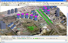
Ability to view and plot image files as a background for design data. Typical uses include the incorporation of aerial photographs, satellite imagery, and scanned images used as a backdrop for the location of existing or proposed features.
Support Dynamic Link Between CAD drawing and Topographical Survey Data, Cadastral Survey Calculation Result.
Support Earth Work Engineering, Long Section & Cross Section Profile and Volume Calculation.
Support Terrain Modeling and contouring with 3D auto dynamic roaming ability.
Support Water Level Analysis with Grid Base modeling & labeling abilities.
Provide Various Engineering Calculation with multiple mathematic models.
Provide localized cadastral calculation with “what you see what you get” reporting system.